The French Alps are the spiritual home of road cycling. The cols that have decided Tour de France stages for a century — the Galibier, the Izoard, Alpe d’Huez — are open to any cyclist willing to turn up and suffer. No support team required, no entry fee, no crowd. Just the road, the altitude and the knowledge that you are riding the same tarmac as Coppi, Merckx and Pogačar. This is our guide to the 15 most legendary cycling climbs in the French Alps: what to expect, how hard they really are and how to get there.
🚴 In this guide:
- 15 hors-catégorie and Category 1 climbs — from Tour de France legends to hidden Savoie gems
- Route profiles, access points and difficulty ratings for each climb
- Train access notes — many climbs are reachable without a car
- Check the Alpine pass opening dates before planning — some cols don’t open until late June
1. Col du Galibier (2,642 m) — the legendary col

The Galibier is the benchmark Alpine climb — and the one most cyclists mean when they say they want to ride “a proper French col”. At 2,642 m, it sits between the Northern and Southern Alps and has been crossed by the Tour de France 63 times. Whichever side you approach from, this is a serious undertaking: 35 km from the Maurienne valley (Saint-Michel-de-Maurienne) via the Col du Télégraphe, or 35 km from Briançon in the south, or nearly 50 km from Bourg-d’Oisans. All approaches are classified hors catégorie.

Start points: Saint-Michel-de-Maurienne (Savoie) · Bourg-d’Oisans (Isère) · Briançon (Hautes-Alpes). The Maurienne side has a convenient SNCF station at Saint-Michel Valloire — all trains take bikes.
Difficulty: hard — long rather than steep, but relentless
Tour de France: 63 crossings or summit finishes · hors catégorie
Setting: the north approach passes through the village of Valloire and climbs in full alpine nature; the south approach comes up through the Serre Chevalier valley. If you ride from the Maurienne in June or early July, the final kilometres pass between walls of snow several metres high — one of the great alpine cycling experiences. Full route profile →
2. Mont Ventoux (1,910 m) — the Giant of Provence

Ventoux is perhaps the most famous cycling climb in the world — and rightly so. It dominates Provence from 1,910 m and can be approached from three sides: Bédoin (south, classic Tour route), Malaucène (north) and Sault (east, the gentler approach). The Bédoin ascent is the most brutal: after a gentle start through vineyards, 8 km of forest climbing at over 10% followed by the final exposed limestone moonscape — no shade, full sun, wind that can be ferocious. The Tour has crossed it 18 times, with 10 summit finishes. Technically not in the Alps, but no serious alpine cycling list omits it.

Start point: Vaison-la-Romaine (for a proper warm-up before the Bédoin approach) or Bédoin direct
Difficulty: very hard — arguably the hardest climb on this list in summer heat
Tour de France: 18 crossings · hors catégorie
Setting: vineyards and lavender fields at the base give way to dense forest on the hardest section, then the famous bare white limestone summit — visible from 50 km away across Provence. Full route profile →
3. Col de la Croix de Fer (2,067 m) — the panoramic col

Between the Oisans and the Maurienne valley, the Croix de Fer is a long and beautiful climb with an approach that builds in stages on both sides. The classic linking of this col with the Galibier in a single day — the legendary Brevet du Randonneur Alpin (BRA), starting from Grenoble — is one of the great French cycling challenges. From the Maurienne side, a variant via the Col du Mollard adds scenic interest.

Start points: Allemond (near Bourg-d’Oisans) · Saint-Jean-de-Maurienne (SNCF station: Saint-Jean-de-Maurienne Arvan)
Difficulty: hard — length rather than gradient is the challenge
Tour de France: 20 crossings · hors catégorie
Setting: the Allemond approach is wild and quiet, passing two reservoir lakes in dramatic high-alpine scenery. The Maurienne approach is more pastoral with charming villages. At the summit, the Aiguilles d’Arves — the iconic triple-pointed peak of the Maurienne — dominate the view. Full route profile →
4. Alpe d’Huez (1,850 m) — the 21 bends

The 21 numbered hairpin bends of Alpe d’Huez are the most recognisable stretch of road in professional cycling. With over 30 Tour de France ascents, this is the closest thing the sport has to a sacred site. The numbers count down from 21 at the bottom — each bend named after a Tour stage winner — and the final hairpin into the resort is genuinely emotional. The climb is 13.8 km at over 8% average, with several sections exceeding 10% in the first half. The last 2 km ease slightly to around 4% — allowing spectacular sprint finishes in the Tour.

Start point: Bourg-d’Oisans — an excellent base for the Galibier, Croix de Fer, Glandon and Col d’Ornon as well
Difficulty: hard but consistent — the gradient doesn’t surprise you
Tour de France: 31 ascents or summit finishes · hors catégorie
Setting: the road is busy and the numbered bends give a rhythm to the effort. The arrival is in a large ski resort — not wilderness — but the views are open and sunny, and the sense of achievement at the top is real. Full route profile →
5. Grand Colombier (1,501 m) — the Jura giant with Alpine views

Technically in the Jura rather than the Alps, the Grand Colombier is close enough to the Alps and hard enough to belong on any serious climbing list. It has four routes to the summit, all classified hors catégorie, and its own cult following — the Fêlés du Colombier, whose members must complete two ascents in a single day to join, and four to become “Grand Maître”. At 1,500 m it dominates the Rhône plains and the Lac du Bourget with a panorama that takes in the full Mont Blanc massif on a clear day.
Start point: Culoz (classic south approach, with the best lake and Alpine views)
Difficulty: very hard — comparable to Mont Ventoux or the Mont du Chat
Tour de France: 4 crossings · hors catégorie
Setting: heavily forested on the way up, opening dramatically at the summit with 360° views across the Jura and to Mont Blanc.
6. Col de l’Izoard (2,362 m) — the Southern Alps legend

The Izoard is among the most atmospheric cols in the Alps — particularly on the southern approach, where the “Casse Déserte” awaits: a lunar landscape of towers and scree, utterly unlike anything else on an Alpine road. At the heart of the Queyras, a remote and unspoilt corner of the Hautes-Alpes, the col has been crossed 26 times by the Tour. The south approach from Guillestre is 31 km but progressive; the north from Briançon is 17 km with a hard final section of 7 km at 9–10%.

Start points: Briançon (north) · Guillestre (south) — the loop combining both sides is the classic approach
Difficulty: hard — the final 7 km from Briançon are particularly demanding
Tour de France: 26 crossings · hors catégorie
Setting: the Queyras national park provides extraordinarily unspoilt scenery on both approaches. The Casse Déserte on the south side — pinnacles of cargneule rock in an almost Martian landscape — is one of the great visual rewards in French cycling. Full route profile →
7. Cormet de Roselend (1,968 m) — one of the most beautiful cols in the Alps

The Cormet de Roselend links the Beaufortain valley to Bourg-Saint-Maurice in the Tarentaise — passing the magnificent Roselend reservoir lake, one of the finest panoramas in the Northern Alps. At 1,968 m, it is a serious climb that builds in stages: the hardest section is the first 10 km from the Beaufort side, through dense forest. The Bourg-Saint-Maurice approach is more regular despite passages at 9%.

Start points: Beaufort or Albertville (SNCF) · Bourg-Saint-Maurice (SNCF). Train between the two stations allows point-to-point rides — all trains take bikes.
Difficulty: hard — the Beaufort forest section is relentless
Tour de France: 12 crossings · Category 1
Setting: at km 12 from Beaufort, the Roselend lake reveals itself — an extraordinary sight with the surrounding peaks reflected in still water. One of the most rewarding views available to a cyclist anywhere in the Alps. Full route profile →
8. Col du Glandon (1,924 m) — a genuinely hard col
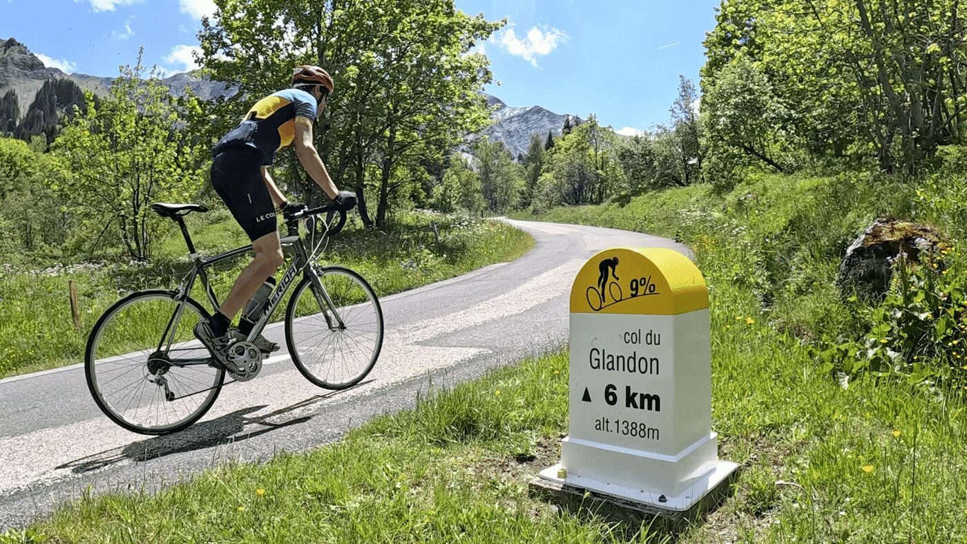
The Glandon climbs the Villards valley in a wilder, less-visited atmosphere than its neighbours. Two distinct stages: dense forest first, then open high alpine meadows above Saint-Colomban-des-Villards. In roughly 15 km, you climb from 500 m to nearly 2,000 m. The final 8 km are consistently above 8%, with the last 2 km exceeding 10%. On its south side, the Glandon connects directly to the Croix de Fer road — allowing a classic loop between the two cols.

Start point: Saint-Étienne-de-Cuines (Maurienne) — 3 km from La Chambre SNCF station
Difficulty: hard — the sustained final section makes it particularly demanding
Tour de France: 13 crossings · hors catégorie
Setting: wild and unspoilt, moving from vineyards at valley level through villages and forest to high alpine pastures. From the summit, Mont Blanc appears on the horizon beyond the Col de la Madeleine. Full route profile →
9. Col de la Madeleine (1,993 m) — the south-facing Savoie classic

The Madeleine links the Maurienne to the Tarentaise at 1,993 m — crossed 27 times by the Tour de France. The south approach, on a hot exposed road through hamlets and the small resort of Saint-François-Longchamp, is the more challenging. The north approach is longer, more authentic and passes through quieter, less-visited villages. In winter, the top of the road is actually a green ski run — a pleasant irony for summer cyclists.

Start points: La Chambre (Maurienne, SNCF) · La Léchère (Tarentaise, SNCF) — a point-to-point between two stations is easy to organise
Difficulty: hard — the south face is hot and exposed
Tour de France: 27 crossings · hors catégorie
Setting: flowering alpine meadows, stone hamlets and the sharp peaks of the Lauzière range. The area has an authenticity that the major resort valleys lack. Full route profile →
10. Col de Joux Plane (1,691 m) — Haute-Savoie hard man with Mont Blanc views

Short by Alpine standards but uncompromisingly hard, Joux Plane connects Morzine and Samoëns through a 10 km climb with several sections exceeding 9% — irregular gradients that make it harder to pace than the more consistent giants. The summit reward is an exceptional Mont Blanc panorama, one of the finest viewpoints available from a paved Alpine road.

Start points: Morzine · Samoëns
Difficulty: hard — irregular gradient makes it harder to pace than the big cols
Tour de France: 11 crossings · hors catégorie
Setting: forest on the way up, then alpine pastures opening to the Mont Blanc panorama. Both Morzine and Samoëns are attractive villages to base yourself. Full route profile →
11. Col de l’Iseran (2,764 m) — the highest paved Alpine pass

At 2,764 m, the Iseran is the highest paved mountain pass in the Alps — and one of those climbs where altitude itself becomes the challenge. The road can close without warning in summer when snow falls. The most dramatic approach is from the south, starting from Modane or Bonneval-sur-Arc through the Vanoise national park; the Val d’Isère side from Bourg-Saint-Maurice is equally impressive but more touristic. Both full approaches are close to 50 km.

Start points: Modane (SNCF) · Bourg-Saint-Maurice (SNCF) for full approaches. Starting from Val d’Isère or Bonneval-sur-Arc reduces the climb to around 900 m of ascent.
Difficulty: very hard from Modane or Bourg; moderate from the intermediate villages
Tour de France: 8 crossings · hors catégorie
Setting: the Vanoise national park at its most dramatic — glaciers, high pastures, marmots everywhere. Bonneval-sur-Arc at the southern foot is one of the most beautiful villages in France. Full route profile →
12. Mont du Chat (1,486 m) — the Ventoux of Savoie

Modest in altitude but immodest in gradient, the Mont du Chat earns its nickname “the Ventoux of Savoie” through sheer relentlessness: over 10 km of straight, consistent 10% gradient through dense forest, with almost no view until the summit reveals Lac du Bourget and the full Alpine panorama in one breathtaking sweep. Only two Tour de France ascents so far, but its cult status among local cyclists is already established.

Start points: Le Bourget-du-Lac · Meyrieux-Trouet. A loop via the Col du Chat and Col de l’Épine makes an excellent full day.
Difficulty: very hard — monotonous gradient demands strong mental as well as physical reserves
Tour de France: 2 crossings · hors catégorie
Setting: almost entirely forested — the forest actually helps in summer heat. The summit view over Lac du Bourget is the payoff. Full route profile →
13. Col du Petit-Saint-Bernard (2,188 m) — the rolling pass to Italy

The Petit-Saint-Bernard is the most accessible cross-border col on this list — a rolling, enjoyable road from Bourg-Saint-Maurice through the ski resort of La Rosière to the French-Italian border at 2,188 m. It is one of the few historic passes on the list that most intermediate cyclists will enjoy rather than merely survive. The promise of Italy at the top — and the Italian descent to Pré-Saint-Didier — is a genuine motivation. The variant via Montvalezan is considerably harder.

Start point: Bourg-Saint-Maurice (SNCF) or Pré-Saint-Didier (Italy)
Difficulty: moderate — one of the more accessible cols on this list
Tour de France: 4 crossings + one La Rosière stage finish · Category 1
Setting: a sunny, well-surfaced balcony road with Mont Blanc views on the Italian side — one of the most pleasant riding experiences in the Alps. Full route profile →
14. Cime de la Bonnette (2,802 m) — the highest road in the Alps

The Cime de la Bonnette is not technically the highest col (the actual pass, Col de la Bonnette, sits at 2,715 m) — but the loop road around the summit reaches 2,802 m, making it the highest paved road in the Alps. It links the Ubaye valley (Jausiers) to the Tinée valley (Saint-Étienne-de-Tinée) through 25 km of climbing with sections at 9%. The surrounding landscape becomes progressively more mineral and dramatic as altitude increases — a genuinely remote and exceptional ride.
Start points: Jausiers (Ubaye valley) · Saint-Étienne-de-Tinée (Tinée valley)
Difficulty: hard — 25 km with sustained gradients at altitude
Tour de France: 4 crossings · hors catégorie
Setting: the Southern Alps at their most mineral and remote — dark rock, high pastures and enormous skies in the Mercantour national park.
15. Col de la Loze (2,304 m) — the outlier

Start point: Moutiers (SNCF)
Difficulty: brutal — sections exceed 14%, with irregular gradient that makes pacing almost impossible
Tour de France: 2 crossings · hors catégorie
The newest col on this list — the last road in France built exclusively for cyclists, on a former ski domain access track between Méribel and Courchevel in the Three Valleys. It is also the most controversial: sections exceed 14% alternating with near-flat stretches, making it almost unrideable at consistent effort. Entirely within the ski domain, it offers little wild scenery — but for masochists who want the hardest climbing available on a paved road, it delivers. Full route profile →
Planning your Alpine cycling trip
Most of the cols on this list are open from mid-June to mid-October, with some (Iseran, Bonnette, Galibier) opening later and closing earlier depending on the year’s snowpack. Always check opening dates before travelling — arriving to find a col closed for snow is a frustrating experience. Several cols are accessible by train without a car — the SNCF accepts bikes on all regional trains in the Alps, and many of the best start points (Saint-Michel-de-Maurienne, Saint-Jean-de-Maurienne, Bourg-Saint-Maurice, Modane) are on the main Chambéry–Turin line.
👉 Read also: Cycling around Lake Annecy · Cycling around Lac du Bourget · Free alternatives to the Mont Blanc Tunnel