The French Alps are an extraordinary hiking destination — and what makes them special is the existence of objectives. When you walk in the Alps, you are going somewhere: a lake, a summit, a waterfall, a chapel, a viewpoint. These ten hikes reveal the full diversity of the Northern French Alps. They are often beautiful, well-frequented and within range of the major towns. For something more contemplative and less crowded, consider going in September or October — or exploring the many equally fine summits nearby that most visitors never find.
La Tournette (Aravis) — finest viewpoint above Lake Annecy

La Tournette is the highest summit directly overlooking Lake Annecy. The ascent is not technical but it is a proper mountain hike — 1,200 m of ascent to reach the 2,351 m summit. Access is from the Col de la Forclaz or from the Chalet de l’Aulp (if your car can manage the track, you can park there and shorten the approach). At the top, the view is completely open: Lake Annecy below, the Mont Blanc massif to the east, the Vanoise and the Écrins beyond. Ibex are frequently seen on the upper section.
Ascent: 1,200 m · Summit: 2,351 m · Difficulty: sustained, non-technical · Full route profile →
Dent du Chat (Savoie) — panoramic view over Lac du Bourget

The Dent du Chat projects its shadow across Lac du Bourget like a sundial each afternoon. The ascent is relatively steady rather than technically demanding, though the final section is pleasantly airy (it is a “tooth” after all). Access from several points: the Col du Chat, the Signal du Mont du Chat or Le Bourget-du-Lac town itself — the summit is waymarked directly from the town centre for those who want to start on foot. That option gives around 1,000 m of ascent, almost entirely through cool forest. At the top: the Alps and the Jura on one side, the Savoyard foothills on the other.
Ascent: 700–1,000 m depending on start point · Summit: 1,390 m · Difficulty: moderate to sustained
Mont Granier (Chartreuse) — the legendary limestone cliff
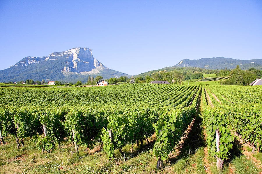
The Granier is an impressive summit — its sheer cliff face has dominated the local imagination for centuries. In 1248, a catastrophic rockfall from the Granier buried the Chambéry valley, creating a rolling landscape of hillocks now planted with vines, known as “Les Abymes”. The mountain is still monitored closely today and occasionally sheds rock (particularly during freeze-thaw cycles). The hike is a long approach through unspoilt nature with some ladder sections, leading to a Chartreuse summit with views over Mont Blanc, Belledonne and much of the Alps.
Ascent: approx. 1,000 m · Summit: 1,933 m · Difficulty: sustained, some ladder sections · Full route profile →
Lac Achard (Belledonne) — finest hike near Grenoble

A classic of the Isère hiking scene — occasionally on the verge of overtourism, but a genuinely beautiful high-altitude lake in the Belledonne range, exceptionally accessible from Chamrousse. One of the finest natural sites within easy reach of Grenoble. From the lake, the route can be extended to higher altitude towards the Lacs Robert — or you can consider the full Belledonne traverse for a multi-day adventure.
Ascent: 300–500 m from Chamrousse · Altitude: 1,917 m · Difficulty: easy to moderate · Full route profile →
Dent d’Oche (Chablais) — vast panorama over Lake Geneva

The Dent d’Oche dominates Thonon-les-Bains and Lake Geneva from its 2,222 m summit. The ascent is slightly technical in places, with 1,200 m of total gain — but the reward at the top is a 360° panorama over the Alps, Lake Geneva and the Jura range. Just below the summit, the Refuge de la Dent d’Oche offers overnight accommodation and meals — making this an excellent first mountain hut experience, with a short approach on day two.
Ascent: 1,200 m · Summit: 2,222 m · Difficulty: sustained, slightly technical
Dent de Crolles (Chartreuse) — the Grenoble classic

The definitive Grenoble hike — this magnificent Chartreuse summit is the second highest peak in the massif at 2,062 m, dominating the Grésivaudan valley and Grenoble below. Accessed from the Col du Coq in only 660 m of ascent, it exemplifies the striking contrast typical of the pre-Alpine limestone massifs: sheer cliff on the Grésivaudan side, gentle alpine pasture on the Chartreuse side. At the top: views over Chartreuse, Belledonne and the Mont Blanc massif.
Ascent: 660 m from Col du Coq · Summit: 2,062 m · Difficulty: moderate · Full route profile →
Lac Blanc (Aiguilles Rouges) — the unmissable Chamonix hike ⭐

One of the most photographed mountain scenes in the French Alps — and justifiably so. This high-altitude lake at 2,352 m in the Aiguilles Rouges massif faces the full Mont Blanc chain directly, its glaciers and permanent snowfields reflected in the still water. Access from Tré-le-Champ (1,000 m ascent) or from the top of the Flégère cable car (500 m ascent). A mountain refuge sits beside the lake — a stage on the Tour du Mont Blanc route.
Ascent: 500 m from Flégère, 1,000 m from Tré-le-Champ · Altitude: 2,352 m · Difficulty: moderate (cable car option) to sustained · Full route profile →
Mont Thabor (Maurienne) — 3,178 m at the crossroads of the Alps

Mont Thabor stands at the junction of the Northern and Southern Alps, between Savoie, the Hautes-Alpes and Italy. At 3,178 m it is a genuinely high summit — lunar, preserved and among the most unspoilt corners of this part of the Alps. At the top stands an Italian chapel, the site of an annual pilgrimage. The strong contrasts of shadow and light at this altitude mean an early start is advisable. Access from Valfréjus or Valmeinier — the Valfréjus approach via Le Lavoir is the most direct as a day trip. Several mountain huts are found on the route. The summit view takes in the Vanoise, the Écrins and numerous Italian peaks.
Ascent: approx. 1,400 m from Valfréjus · Summit: 3,178 m · Difficulty: sustained, high altitude · Full route profile →
Grand Veymont (Vercors) — panoramic summit of the pre-Alps

The Grand Veymont is the highest point of the Vercors at 2,341 m — a great classic for Grenoble hikers, alongside the Dent de Crolles and the Croix de Belledonne. The approach from Gresse-en-Vercors involves over 1,100 m of ascent, rewarded by excellent views over the Vercors ridgeline, the Dévoluy and the Écrins massif. The highlight along the way is the view of the magnificent Mont Aiguille — one of the most distinctive rock formations in the French Alps, a natural monolith that rises 300 m sheer from the plateau.
Ascent: 1,100+ m from Gresse-en-Vercors · Summit: 2,341 m · Difficulty: sustained · Full route profile →
Plateau d’Emparis (Oisans) — facing the Écrins glaciers ⭐

One of the iconic sites of the Northern French Alps — a beautiful plateau dotted with lakes, facing the Écrins glaciers and the imposing La Meije peak directly. Access from Le Chazelet (Hautes-Alpes) or Besse (Isère), with around 1,000 m of ascent from either starting point. Both villages are among the most beautiful in the French Alps. The Emparis plateau is at its most extraordinary in September and early October, when the low autumn light catches the glaciers and the plateau grasses have turned to gold.
Ascent: approx. 1,000 m · Altitude: 2,450 m (plateau) · Difficulty: sustained · Full route profile →
👉 Read also: French Alps in September — best hiking month · French Alps in June · Best via ferratas in the French Alps · 15 legendary cycling climbs in the French Alps